Imagine waking up to sun on the water, launching a kayak before work, and strolling downtown for dinner with river views. That is the Fox River lifestyle many buyers love in St. Charles. If you are considering it, a little homework on flood maps, insurance, shorelines, and permits will help you buy with confidence. This guide walks you through the essential checks, from elevation certificates to dock rules, with practical next steps tailored to St. Charles and nearby Elgin in Kane County. Let’s dive in.
Start with flood maps and elevation
Before you fall for a view, confirm the property’s flood status. The City of St. Charles uses FEMA Flood Insurance Rate Maps to determine both lender requirements and local regulation, and the City Engineering office keeps many properties’ Elevation Certificates on file. You can request parcel-specific help and access floodplain resources through the City’s Engineering Division. Visit the City’s floodplain information page to confirm map status and ask about existing elevation certificates maintained since the 1990s. You can reach the City’s resource hub at St. Charles Floodplain Information.
Once you know whether the home or structure sits inside a FEMA Special Flood Hazard Area, you can plan insurance and financing. If a structure is mapped inside an SFHA and you use a federally backed mortgage, the lender will require flood insurance. Even outside the SFHA, a lender may choose to require coverage, so ask early in the process.
What flood zones mean for your loan and insurance
Flood insurance pricing changed under FEMA’s Risk Rating 2.0. Rather than just a zone label, premiums now reflect several property-specific factors like distance to water, elevation, building characteristics, and replacement cost. The result is that premiums can go up or down compared with legacy pricing. Get a quote for both an NFIP policy and a private-market option to compare. To learn how Risk Rating 2.0 works, review FEMA’s overview at NFIP Risk Rating 2.0.
If coverage is required, your lender will want proof in place prior to closing. An Elevation Certificate can help refine the quote. If the home’s lowest floor is higher than the base flood elevation, that can improve pricing. Keep your insurance agent, lender, and City Engineering contact aligned so documents flow smoothly.
If the map looks wrong: LOMA and LOMR-F
Sometimes a structure is shown inside the SFHA even though a certified survey proves it sits above the base flood elevation. In those cases, an owner can request a FEMA Letter of Map Amendment or, if fill was used, a Letter of Map Revision based on Fill. Approved determinations can remove the federal insurance requirement for that structure, though a lender may still choose to require coverage. Start with FEMA’s guidance at Change Your Flood Zone. Reviews can take weeks to a few months and require certified elevation data.
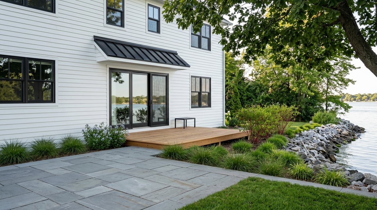
Shorelines, docks, and who permits what
When you buy on the Fox River, understand that riparian rights exist within a layered permit framework. Illinois case law supports reasonable, noncommercial riparian uses like access and docking, but state and federal agencies still regulate work that affects public waters and floodways. A statement in your deed does not replace needed permits. For background on riparian rights in Illinois, see the statute referenced at Illinois Riparian Rights.
At the state level, the Illinois Department of Natural Resources Office of Water Resources issues permits for work in or affecting rivers, public waters, and floodways. Projects such as docks, bulkheads, revetments, and certain shoreline stabilizations often require permits or may qualify under general authorizations. Review program details at IDNR Permit Programs.
Federally, the U.S. Army Corps of Engineers regulates work in navigable waters and the discharge of dredged or fill material. Many in-water or bank projects trigger Corps review, sometimes along with IEPA water-quality coordination. Learn the basics at USACE Regulatory Program.
Locally in St. Charles, start with the City Engineering office. Ask for written confirmation of any prior shoreline or dock permits, whether a dock is legally allowed at that parcel, and whether any public-use easements or encumbrances exist. The City is also your go-to for floodplain permitting and historical Elevation Certificates. Access the City hub at St. Charles Floodplain Information.
River-specific risks and upkeep to budget
Inland rivers like the Fox bring unique conditions. You will encounter riverine flooding potential, gradual or storm-driven bank erosion, and winter ice or debris movement. Seasonal operations upstream, such as Stratton Lock and Dam on the Fox Chain, can influence pool levels and short-term river behavior. For timing and operations context, review IDNR’s resource pages at IDNR Water Resources.
Budget for shoreline and access upkeep over time. Common items include repairing riprap or revetments, managing riverbank vegetation, addressing tree loss after undermining, inspecting and maintaining docks or lifts, and planning for seasonal removal if required. Costs vary widely by site. Small floating dock upkeep can be modest, while engineered bank stabilization can run into tens of thousands of dollars depending on length, complexity, and any mitigation conditions tied to permits.
Upgrades that can improve resale and insurance
Practical mitigation steps often help both your premium and your future buyer appeal. Consider raising or flood-proofing mechanicals like the furnace, water heater, and electrical panel. Where appropriate, install flood vents or engineered breakaway walls for lower enclosures. Document your elevation with an Elevation Certificate to support pricing or a future map-change request. When contemplating shoreline improvements, ask about natural or “living shoreline” solutions where permitted. Coordinate early with City Engineering and IDNR so your plans align with permit requirements. You can review state permit guidance at IDNR Permit Programs and local floodplain resources at St. Charles Floodplain Information.
Financing, disclosures, and resale realities
If your target property is inside an SFHA and you use a federally backed mortgage, plan on carrying flood insurance. Your lender will require evidence of coverage before closing and will outline acceptable policy types. Elevation Certificates and approved FEMA map-change determinations may alter lender requirements, but they must be presented in time for underwriting.
For disclosures, Illinois sellers must disclose known material defects and conditions, which includes past water intrusion or flooding, on the state form. As a buyer, ask for a written flood history, copies of any prior claims, mitigation work with permits, and all available elevation and LOMA documentation. The City’s Engineering page is a useful local resource for confirming what records exist at St. Charles Floodplain Information.
Market context at a glance
Waterfront pricing in St. Charles spans a wide range. The premium is not a one-size number. It depends on lot size and elevation, direct water access and docking rights, quality and age of the home, and how much ongoing shoreline responsibility you inherit. When you evaluate a riverfront home, use nearby riverfront comparables, not just inland comps, and factor lifetime costs like insurance and shoreline upkeep into your offer strategy.
Due diligence checklist for St. Charles and Kane County
Use this quick, local checklist to keep your purchase on track:
- Verify flood zone and elevation. Pull the parcel on FEMA’s map viewer and ask St. Charles Engineering whether an Elevation Certificate exists on file. Start here: St. Charles Floodplain Information.
- Get insurance quotes early. Compare an NFIP quote with at least one private-market option. Pricing now reflects Risk Rating 2.0 factors. Learn more at NFIP Risk Rating 2.0.
- Ask your lender about requirements. Confirm whether they accept private policies, and whether they will need an Elevation Certificate or a FEMA LOMA before closing.
- Confirm permits and riparian status. Request dock permits, shoreline stabilization permits, and any deed language related to riparian rights. Review the legal context at Illinois Riparian Rights and the state permit framework at IDNR Permit Programs.
- Inspect the shoreline with intent. Look for bank undermining, recent repairs, high-water staining on structures, dock and lift condition, and the height of mechanicals relative to the lowest floor. For severe stability concerns, consider a local civil or geotechnical opinion.
- Check county-level flood context. For planning-level drainage and mitigation information, review Kane County’s floodplain and water resources pages at Kane County Floodplain and Water Resources.
- Consider Elgin and other Kane County sections. The Fox River corridor shares state and federal rules, but local contacts differ. If you look in Elgin or another municipality, call that city’s engineering or public works office to confirm local permits and records.
- Plan for ownership costs and resale. Build a simple forecast that includes insurance, routine dock and shoreline maintenance, and any anticipated mitigation. Use nearby riverfront comps for pricing strategy.
Next steps
A strong riverfront purchase comes down to three things: getting the flood and elevation facts right, confirming what you can legally do on the shoreline, and understanding the long-term maintenance picture. With those boxes checked, you can focus on views, access, and lifestyle without surprises. If you want a streamlined process, align your lender and insurance agent early, loop in City Engineering for records, and gather permits and disclosures during attorney review.
If you are ready to explore Fox River homes in St. Charles or nearby Elgin, partner with a local advisor who combines data, process, and on-the-ground coordination. Kathie Frerman offers high-touch buyer representation backed by modern search tools, disciplined transaction management, and deep suburban market knowledge. Reach out to discuss your goals, set up a tailored search, and map a clear path to the riverfront life you want.
FAQs
Do I need flood insurance for a Fox River home in St. Charles?
- If the structure is in a FEMA Special Flood Hazard Area and you use a federally backed mortgage, your lender will require flood insurance, and some lenders may require it even outside mapped zones.
How do I check a St. Charles property’s flood status and elevation?
- Contact City Engineering for the parcel’s mapped status and to request any existing Elevation Certificates, and review resources at St. Charles Floodplain Information.
What permits do I need to add or repair a dock on the Fox River?
- Most in-water or shoreline work requires state review by IDNR and may require federal review by the U.S. Army Corps of Engineers, plus local coordination with St. Charles Engineering.
Can an Elevation Certificate lower my flood insurance premium?
- Yes, because NFIP pricing under Risk Rating 2.0 considers elevation and building characteristics, a current Elevation Certificate can refine your quote and support a future map-change request if eligible.
If a map places my home in the flood zone by mistake, what can I do?
- You can apply to FEMA for a Letter of Map Amendment or, if fill is involved, a Letter of Map Revision based on Fill; see Change Your Flood Zone for steps.
Are Fox River homes in Elgin regulated the same way as in St. Charles?
- The same state and federal rules apply along the river, but local contacts and processes vary by city, so call Elgin’s engineering or public works office for site-specific records and permits.